
Update 3:
Here are the Ten Lakes Topo Maps from Google Earth and Official Maps (cut up) for our hike!
Couple of last minute thoughts:
- Don’t forget to bring some clothes and a towel to sleep in at Mammoth.
- When we park in Yosemite we cannot leave any smelly things in the car. There will/should be a bear locker nearby, but it is an honor code system so don’t plan to put anything valuable there.
- The trip to Ten Lakes may be a direct route (same as coming back). The outgoing plan that I had may have followed a county line instead of a trail. Lisa will confirm the trail when she gets the permit.
- The backup plan is to go to Young Lakes via Dog Lake if we cannot get a trail permit.
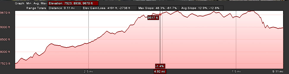
- Getting there: Exit Yosemite Valley on highway 120. Take a left at the gas station following highway 120 for 19.5 miles to the Yosemite Creek / Ten Lakes trailhead, which is clearly marked. There is paved parking on the right side and dirt parking on the left. The trailhead is about 20 yards from the road. Although I have seen two different topographic maps with very different mileage estimates, the trailhead sign notes the distance for Grant Lakes at 5.8 miles and Ten Lakes at 6.3 miles.
- Bring cash to give to Amelia for dinner, permits, yosemite entrance fee, and bear bins (if needed).
Update 2:

Okay everyone. I’m still waiting for an email from the Forest Service about trail conditions, but baring any really bad reports we will be going to Ten Lakes via the path marked on 2011 yosemite backpacking options (google earth). From the map I’ve placed on Google earth it looks like its about 9.2 miles going there and 6.3 miles back. We will start at the Tioga Road start and where our trail intersects with the White Wolf path we will take a bit or a detour to go up along the ridge for some great views of the Grand Canyon of the Tuolomne before we drop down into the Ten Lakes area. I’m not gonna lie, but I think this will be a somewhat challenging hike getting there. On the way we will head straight back to our cars for a long drive home (probably after we stop by the gas station to eat.
From Ten Lakes
Ten Lakes Topographic Map
The Plan
-
Travel Plans
- Car 1 (Lisa, Amelia, Suzanne):
- Leaving Weds or EARLY Thursday.
Will be getting backpacking permits at 11am on Thursday in Yosemite and bear canisters
- Leaving Weds or EARLY Thursday.
- Car 2 (Brian, Tom, Paul) :
- Leaving Thursday (8/11) around 2-4 (TBD)
We will be sleeping at Lisa’s grandparents house the first night. Bring a set of clothes to sleep into and keep your next days clothes handyWe will change into some clean clothes on the way home at the gas station and get home late Sunday night (8/14)
-
Backpacking-Supply-List
- Make sure you go through the checklist
- It is probably going to be buggy. Bring bug spray! Also, I went and got a mosquito netting for my head and we have a couple of mosquito nets that might fit us (we have never used them).
-
Sleeping Arrangements
- Lisa and Brian (Tent 1)
- Amelia and Suzanne (Tent 2)
- Tom and Paul (Tent 3)
-
Food
Day 1
-
- Breakfast: at Mammoth (TBD)
- Lunch on trail: You are on your own
- Dinner: Lisa and Amelia are picking up dehydrated food and smore stuff. Let us know if you are picky. Bill to come.
- Fish? if we catch some. I’ll have lemon pepper and aluminum foil
Day 2
-
- Breakfast: You are on your own
- Lunch on trail: You are on your own
- Dinner: Lisa and Amelia are picking up dehydrated food and smore stuff. Let us know if you are picky. Bill to come.
- Fish? if we catch some. I’ll have lemon pepper and aluminum foil.
Day 3
-
- Breakfast: You are on your own
- Lunch: At the gas station
- Dinner: Somewhere in bishop or at home
Update 1:
After looking at things a bit more, I’m thinking that the Ten Lakes hike would be nice. I’ve uploaded a new Google Earth file (2011 Yosemite backpacking options (google earth)) that shows the planned hike. It is somewhat of a loop and should be fun to see different things hiking each way. Next step is to call the Forest Service to see if the trails aren’t still snow packed
Backpacking Ideas (7/17/2011)
Gearing to go on our annual group backpacking trip this will be the third year doing this. I think this year we will do a hike out of Yosemite hopefully to an area that isn’t too crowded. So far here are my ideas with a few links to some reviews and maps
Yosemite
Tuolumne Meadows
- Young Lakes via Glen Aulin (6.0) – 4 persons
- Young Lakes via Dog Lake (6.0) – 8 persons
- Ireland Lake (11.4) – 16 persons
- May Lake via Murphy Creek (6.3) – 10 persons
Tioga Road
- Ten Lakes via White Wolf Campground (9.5) – 10 persons?
- Ten Lakes via Ten Lakes trail (6.2) – 16 persons
Notes and Maps
- (Distances are one way)
- Trailhead Information
- Upclose Trails
- Plan your visit PDF
- 2011 yosemite backpacking options (google earth)
Hey! I hope we can go to Ten Lakes – sounds beautiful!!! I am reading Backpacker magazine and they highlight one overnight hike in each state. Here’s the California highlight:
Kibble Ridge Trails – Yosemite
A park ranger says it’s his top overnight in the Sierra.
There is a lake you camp at “Many Islands Lake” – you can swim to the islands.
Just throwing it out there!!! Can’t wait!
finally just got my internet working and got to check this out! Ten lakes sounds amazing! I’ll also call and find out about bugs…hehe…but have no fear, I’ll buy pants and the netting!!!! Thanks for all your work on this!!!! Can’t wait!